The soils on the upland parts of the Old Seneca Turnpike and Gully Road Conservation Area are primarily described as:
- Honeoye-Lima association, gently sloping, deep, well drained and moderately well drained, high-lime soils that have a medium-textured subsoil. This association includes the Honeoye, Lima, Kendia, and Aurora silt loams and Lyons soil.
- Farmington-Aurora association, sloping, shallow, well-drained, and moderately deep, moderately well drained, high- to low-lime soils that have a medium-textured to moderately fine textured subsoil, on uplands.
- Aurora-Farmington-Rock outcrop association, steep, moderately deep and shallow, well drained and moderately well drained, high- to low-lime soils that have a medium-textured to moderately fine textured subsoil; and Rock outcrop; on uplands.
- Aurora-Angola-Darien association, gently sloping, moderately deep and deep, moderately well drained and somewhat poorly drained, medium- and high-lime soils that have a medium-textured to moderately fine textured subsoil; on uplands.
- Teel-Hamlin-Wayland association, level, deep, well-drained to somewhat poorly drained, medium- and high-lime soils that have a medium-textured to moderately coarse textured subsoil; and deep, poorly dra{ned and very poorly drained, medium- and hign-lime soils that have a medium-textured to moderately fine textured subsoil; on flood plains.
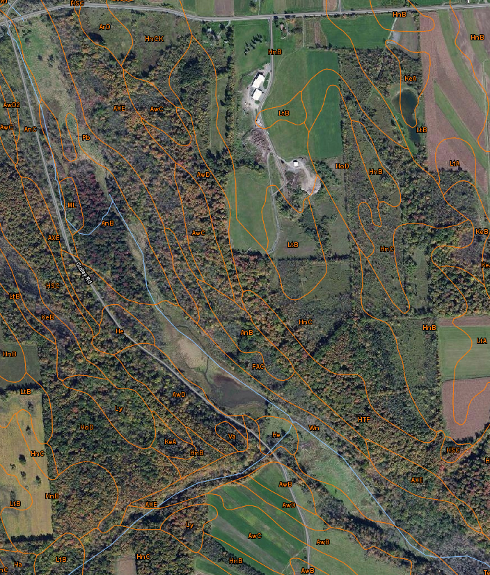 |
| USDA-NRCS soil map for the Old Seneca Turnpike and Gully Road Conservation Areas |
| Symbol |
Soil type |
Acres |
Percent |
| AnB |
Angola-Darien silt loams, 0-6% slopes |
30.0 |
4.3% |
| AnC |
Angola-Darien silt loams, 6-12% slopes |
13.7 |
1.9% |
| ArD |
Arkport very fine sandy loam, hilly |
4.9 |
0.7% |
| AwB |
Aurora silt loam, 0-6% slopes |
17.6 |
2.5% |
| AwC |
Aurora silt loam, 6-12% slopes |
29.9 |
4.2% |
| AwD |
Aurora silt loam, 12-18% slopes |
23.0 |
3.3% |
| AwD2 |
Aurora silt loam, 12-18% slopes, eroded |
1.3 |
0.2% |
| AXE |
Aurora-Farmington-Rock outcrop association, steep |
55.1 |
7.8% |
| FAC |
Farmington-Aurora association sloping |
11.4 |
1.6% |
| Ha |
Halsey mucky loam |
2.7 |
0.4% |
| He |
Herkimer silt loam |
7.6 |
1.1% |
| HnB |
Honeoye silt loam, 2-8% slopes |
137.1 |
19.5% |
| HnC |
Honeoye silt loam, 8-15% slopes |
89.6 |
12.7% |
| HnCK |
Honeoye silt loam, rolling |
12.9 |
1.8% |
| HoD |
Honeoye and Lansing gravelly silt loams, 15-25% slopes |
39.0 |
5.5% |
| HSC |
Honeoye very stony soils, sloping |
19.4 |
2.8% |
| HTF |
Honeoye, Lansing, and Ontario soils, very steep |
24.0 |
3.4% |
| KeA |
Kendaia silt loam, 0-3% slopes |
8.1 |
1.2% |
| KeB |
Kendaia silt loam, 3-8% slopes |
14.5 |
2.1% |
| LtA |
Lima silt loam, 0-3% slopes |
14.2 |
2.0% |
| LtB |
Lima silt loam, 3-8% slopes |
63.4 |
9.0% |
| Ly |
Lyons soils, 0-3% slopes |
11.1 |
1.6% |
| ML |
Made land |
2.0 |
0.3% |
| Pb |
Palms muck |
22.2 |
3.2% |
| Te |
Teel silt loam |
0.4 |
0.1% |
| Va |
Varick silt loam |
1.3 |
0.2% |
| Wn |
Wayland soils complex, 0 to 3% slopes, frequently flooded |
48.3 |
6.9% |
| Total area indicated in the map above |
704.5 |
100.0% |
Soil reaction is a measure of acidity or alkalinity of a soil, expressed as pH values. A soil that tests to pH 7.0 is described as precisely neutral in reaction because it is neither acid nor alkaline. The degrees of acidity or alkalinity, expressed as pH values, are:
| Ultra acid |
< 3.5 |
| Extremely acid |
3.5 – 4.4 |
| Very strongly acid |
4.5 – 5.0 |
| Strongly acid |
5.1 – 5.5 |
| Moderately acid |
5.6 – 6.0 |
| Slightly acid |
6.1 – 6.5 |
| Neutral |
6.6 – 7.3 |
| Slightly alkaline |
7.4 – 7.8 |
| Moderately alkaline |
7.9 – 8.4 |
| Strongly alkaline |
8.5 – 9.0 |
| Very strongly alkaline |
> 9.0 |
References: